Epsom, UK, 24th February 2022, (www.astuntechnology.com)
Last week’s announcement that the UK Government intends to overturn its 2026 deadline for registering historic paths has been celebrated by The Ramblers, Great Britain’s leading walking charity, and Astun Technology, developers of the Ramblers’ Volunteered Geographic Information mapping tool, Don’t Lose Your Way.
Launched in 2020, Don’t Lose Your Way aimed to build an army of citizen geographers who would help uncover and save generations of lost paths and hidden ways before the 2026 deadline. After a high-profile media campaign, the Ramblers recruited a staggering 3,000 volunteers across England and Wales.
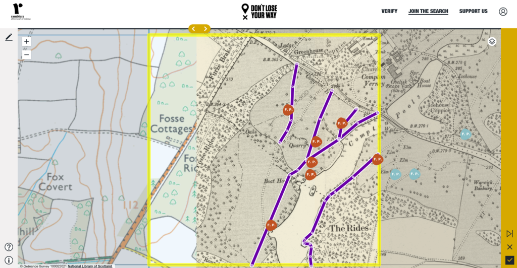
These volunteers used an intuitive online tool developed by Astun to compare current and historic maps side by side. Each of the 154,000 one km square map tiles could be compared with the missing paths being drawn and submitted in a matter of minutes. Collectively, volunteers discovered over 49,000 miles of potentially unrecorded rights of way in England and Wales.
Now, the announcement of the removal of the 2026 deadline in England gives the Ramblers and its volunteers more time to prioritise the paths that will be the most useful additions to the definitive map and submit applications to the highways authorities for their reinstatement.
Jack Cornish, Head of Paths at The Ramblers, comments, “Working with Astun enabled us to produce, for the first time, a comprehensive map of lost paths across England and Wales. With the help of this easy to use tool our brilliant volunteers managed to search the whole country in just six weeks. Now, with their help, we’ll be able to make sure the most important and useful paths are added back to the map and protected for future generations.”
Dan Ormsby, Head of Operations at Astun Technology, adds, “This landmark decision also eases the pressure on local authorities, who are responsible for processing claims for missing rights of way.”
Building a successful Volunteered Geographic Information platform
Dan believes that the Ramblers’ commitment to thinking about what their volunteers would need was key to success. He comments, “The interface was designed to enable novice or time-pressed participants to map a square in minutes and gamified elements helped to keep volunteers engaged.”
Easy-to-use digitizing tools enabled volunteers to trace paths and tracks that were apparent on the historic OS maps but not detailed on current walking maps. Each square was allocated and searched by two volunteers.
Once complete, verifiers cross-checked the annotated maps and combined each square into a final definitive version. A custom-built tool automated the process to stitch the individual vectors into a final seamless path network.
Open source geo technologies used in the build by Astun included OpenLayers, MapProxy, GDAL and PostGIS. Volunteers compared maps from the Ordnance Survey (OS Six Inch and current OS maps at 1:25,000) and Bartholomew Half Inch.
A full case study can be viewed on the Astun Technology website.